http://spatialminds.com/Overland-Navigator-Software/M/B001TM05D0.htm
What do you guys think about this? It looks like a relatively new development, and possibly a worthy purchase for use with a tablet or netbook.
Possibly developed in conjunction with some people at Overland Journal, judging by the logo, and the ad placement at ExPo.
Overland Navigator software
7 posts
• Page 1 of 1
My Build Thread | 2006 Trailblazer LS Desert Camping Edition **SOLD**
2013 Nissan Xterra S "ReXterra"
2013 Nissan Xterra S "ReXterra"
-

Philberto - Lifer
- Posts: 2046
- Joined: Fri Sep 11, 2009 5:30 pm
- Location: CA, Oxnard
- Name: Philip Cruz
- Vehicle Year: Other
- Vehicle: Other Vehicle
- DriveTrain: 4WD
- Rank: Offroad Rated
Seems to be good software. What hardware would be most compatible for the off road environment?
- bgwolfpack
- Veteran
- Posts: 1794
- Joined: Fri Sep 18, 2009 7:19 pm
- Name: Randy
- Vehicle Year: Other
- Vehicle: Other Vehicle
- DriveTrain: 4WD
I was on ExPo when he first showed up, but he's not part of the OJ or ExPo team. Now he's a supporting vendor. Interesting mix of features. I prefer DeLorme products for the most part, and always update Street Atlas and Topo USA when they offer it. The DeLorme library subscription cost for unlimited downloads (limited by a clunky 3-orders at a time restriction) is only $30 a year, and you can snag aerial imagery as well.
I haven't done a feature comparison with this product, but I'll show you National Geographic TOPO! and DeLorme on my tablet in a couple of weeks. I'll also sell you the previous version of Topo USA for cheap, cheap. Maybe a couple of beers would be enough.
Got any USB GPS receivers yet? I might have a left-over one of those as well.
I use a Motion Computing M1400 (second generation) tablet with a sunlight readable display. You can find those really cheap now on Ebay, and they use a regular notebook EIDE 2.5" drive, which can now be as large as 160GB. Toughbooks are also very popular in the ExPo forums. Solid state drive might be better, but I've never had a HD failure in 4 different sizes of drives in four years. I haven't seen an EIDE SSD, though, just SATA. Newer Motion Computing tablets are using the 1.5" Ipod size drives, more expensive to get larger ones.
-

The Roadie - Founder
- Posts: 5011
- Joined: Mon Sep 07, 2009 11:29 pm
- Location: CA, Vista, San Diego County
- Name: Bill Carton
- Vehicle Year: 2004
- Vehicle: GMC Envoy
- DriveTrain: 4WD w/ G80
- Rank: Expedition Guide
bgwolfpack wrote:Seems to be good software. What hardware would be most compatible for the off road environment?
Toughbook Tablet really... they're made by Panasonic:
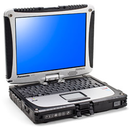
I'd pick up an older used one on eBay. It may be a little overkill, especially if you're not going to use it outside of the car. Otherwise, I've read of people using eee PC from Asus or Acer Aspire Ones (netbooks) for their small size, low cost, and excellent battery life. You just need an external GPS receiver to plug in.
Roadie, I've not made one purchase re: this part of my build yet... I'm going to have a new Android phone with GPS and been looking for off-network Topo software for it, may have to have a buddy develop some. I'll have plenty of beer with me, so I may just take you up on the offer if you want to bring along your old GPS receiver.
My Build Thread | 2006 Trailblazer LS Desert Camping Edition **SOLD**
2013 Nissan Xterra S "ReXterra"
2013 Nissan Xterra S "ReXterra"
-
Philberto - Lifer
- Posts: 2046
- Joined: Fri Sep 11, 2009 5:30 pm
- Location: CA, Oxnard
- Name: Philip Cruz
- Vehicle Year: Other
- Vehicle: Other Vehicle
- DriveTrain: 4WD
- Rank: Offroad Rated
From my recollection when I went GPS software shopping, the overland navigator dataset is fairly large because they don't store "readable data" they store pictures. It's been almost a year though since I went shopping for it, they may have updated since.
I've been using Delorme Topo USA now with some decent success. It's not a perfect product, but better than the others I looked at.
Also, I've just been using my everyday Dell Lattitude on the trails. It gets rattled around a bit, but the ram-mount almost acts as a suspension to soften the bumps.
If you have a laptop and get a ram-mount, make sure you buy a screen support bar. Otherwise your screen will flop around a bit.
-

Trail X - Founder
- Posts: 9935
- Joined: Mon Sep 07, 2009 10:22 pm
- Location: VA, Roanoke
- Name: James Downing
- Vehicle Year: 2005
- Vehicle: Chevrolet TrailBlazer
- DriveTrain: 4WD w/ Aftermarket Locker
- Rank: Expedition Guide
The Roadie wrote:I was on ExPo when he first showed up, but he's not part of the OJ or ExPo team. Now he's a supporting vendor. Interesting mix of features. I prefer DeLorme products for the most part, and always update Street Atlas and Topo USA when they offer it. The DeLorme library subscription cost for unlimited downloads (limited by a clunky 3-orders at a time restriction) is only $30 a year, and you can snag aerial imagery as well.
I haven't done a feature comparison with this product, but I'll show you National Geographic TOPO! and DeLorme on my tablet in a couple of weeks. I'll also sell you the previous version of Topo USA for cheap, cheap. Maybe a couple of beers would be enough.
Got any USB GPS receivers yet? I might have a left-over one of those as well.
I use a Motion Computing M1400 (second generation) tablet with a sunlight readable display. You can find those really cheap now on Ebay, and they use a regular notebook EIDE 2.5" drive, which can now be as large as 160GB. Toughbooks are also very popular in the ExPo forums. Solid state drive might be better, but I've never had a HD failure in 4 different sizes of drives in four years. I haven't seen an EIDE SSD, though, just SATA. Newer Motion Computing tablets are using the 1.5" Ipod size drives, more expensive to get larger ones.
hmmm if he doesnt want those, I might have to take them. A friend of mine want to sell me a laptop fo 100 bucks, and now I would actually have a use for it
04 T.B. with McMeister lift, airraid CAI, flowmaster 40 series, Bridgestone Dueler apt 4's, and a G-80!
Previously known as NickNorie
Previously known as NickNorie
-

That1Guy - Addict
- Posts: 909
- Joined: Fri Sep 11, 2009 6:03 pm
- Location: Oceanside, Ca
- Name: Nick
- Vehicle Year: Other
- Vehicle: Chevrolet TrailBlazer
- DriveTrain: 2WD w/ G80
- Rank: Trail Ready
Philberto wrote:http://spatialminds.com/Overland-Navigator-Software/M/B001TM05D0.htm
What do you guys think about this? It looks like a relatively new development, and possibly a worthy purchase for use with a tablet or netbook.
Looks pretty good, but as mentioned, uses bitmap (picture) topo maps so size requirements can be huge.
My setup starts with a Garmin GPSMap 276c in the Trailblazer, which uses vector (line based) maps. With some memory expansion I can load both driving maps (hotels, gas, points of interest, etc.) and topo maps. I also decided on this because a local company makes 1:10,000 topo maps of Ontario for Garmin.
As Roadie mentioned before, the one problem with this setup is that even though the screen is 480x360, its still is too small when you want to see the big picture or plan for distances (a la MORA extraction).
I have looked into the Toughbooks from time to time but their cost was always prohibitive.
Once I get home, I download everything to the Garmin Roadtrip desktop software on my Mac. I started using this out of necessity but it has grown on me. It can display any of the vector-based maps I currently own (City Navigator NA, TopoUSA 100K, Topo Ontario 10K). I see that Garmin is growing their 24K US topo maps (from west to east), so I will probably start to get those as well.
But since the home computer has unlimited space, I have been on the lookout for really good looking bitmap based maps so that when I overlay my tracks, I can output a graphic that looks better than what I currently do with the vector based ones. The National Geographic set looks promising but pricey again as they sell them by state.
AG

|| Documenting and sharing overland travels ||
|| adventures and expeditions ||
|| Trailblazer modifications ||
-

AlekG - Off-Roader
- Posts: 116
- Joined: Tue Sep 15, 2009 9:29 pm
- Location: Guelph, Ontario, CANADA
- Name: Alek
- Vehicle Year: 2006
- Vehicle: Chevrolet TrailBlazer
- DriveTrain: 4WD w/ Aftermarket Locker
- Rank: Expedition Rated
7 posts
• Page 1 of 1